Why we still say it
Rendalen has called itself one of Scandinavia’s best fishing, hunting and nature destinations for decades. The line is bold. Here is the case behind it.
Many places quietly drop their old taglines. Rendalen has not. The municipality still puts the same line on its tourism leaflets it used in the 1990s, in the same six confident words, with no hedging adjective in front of it.
The line itself
«Welcome to one of Scandinavia’s best fishing, hunting and nature destinations.»
Rendalen municipality, in continuous use since the 1990sIt is the kind of line a Scandinavian small town stopped writing in the early 2000s. Marketing went brand-led; municipalities stopped competing on what was outdoors. The new town strap lines were modest: a clever colour palette, a soft photograph, a noun without a verb. Rendalen kept the verb. It still says welcome, and it still calls itself one of the best.
The line is also testable. Either the fishing holds up, or it does not. Either the hunting holds up, or it does not. Either the nature holds up, or it does not. The piece below is an attempt to take the line at face value and see whether the place still earns it.
The shape of the case
Pick any single activity and somebody else in Scandinavia wins. Lofoten beats Rendalen on saltwater cod. Trysil beats it on lift-served downhill. Pasvik beats it on Arctic experience. Femundsmarka beats it on remoteness on foot. The line works because it does not pick a single category. The line works because three categories share an address.
Four big lakes in one municipality. Storsjøen, Lomnessøen, Sølensjøen, Hyllingen. Trout, sik, røye, grayling. Inland fishing rights administered cooperatively rather than concessioned out.
Moose, roe deer, willow grouse, capercaillie, hare. The hunting calendar reshapes the working year. State-owned forest and registered hunting teams running by inheritance.
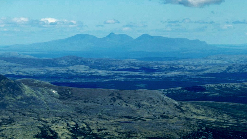
Sølen protected landscape area. Forollhogna national park to the north. Jutulhogget, Northern Europe’s deepest dry canyon. Three thousand square kilometres at a population density below 0.6 per km².
Fishing
The single statistic that has the most weight is the lake count. Rendalen municipality holds four lakes large enough to fish commercially — Storsjøen, the longest, runs almost forty kilometres along the valley. Sølensjøen, the highest, sits at 696 metres and supports the inland fishing village at Fiskevollen. Lomnessøen lies under Otnes. Hyllingen lies in the north. Add to these the smaller mountain lakes — several hundred of them across the plateau — and the Glomma river, which forms the western boundary, and the case for water is dense.
The species mix matters too. Trout and Arctic char in the colder lakes; whitefish and grayling in the warmer ones; pike in the shallows of Storsjøen. The 1913 archaeological find at Fiskevollen — a piece of fishing net dated to the 10th century — suggests the inland fishery is the older of the two: people were taking sik out of Sølensjøen long before they were trawling cod off Lofoten.
What is unusual is the access model. Fishing rights in Rendalen sit with the farms and the cooperatives that grew out of them, rather than with a commercial concessionaire. Permits are sold through inatur.no and on-site. Prices are set to be paid by individuals, not by tour operators.
Hunting
The hunting season is not a hobby in Rendalen. It is a structural part of the year. Schools schedule around the moose hunt in late September and early October. Workplaces accept that some employees will be in the forest at first light. The local hunting teams — jaktlag — are registered to a particular area of state forest or private holding, and most have run continuously for two or three generations.
Moose are the headline species. The municipality issues hunting permits each year through Statskog and the private landowners. Roe deer have moved north over the past two decades and are now established. Willow grouse and capercaillie give the autumn its longer season, from September through to the new year. Hare and ptarmigan round out the small-game list.
The infrastructure follows the practice. Rifle ranges in three of the bygder. Game-processing facilities for moose carcasses near Bergset. A hunting dog culture — mostly Norwegian elkhound and various pointers — that the kennel club rates as one of the most active in Innlandet. Forollhogna national park to the north, which borders the municipality, is open for regulated reindeer hunting.
The terrain does most of the work. Rendalen sits at the southern edge of the Scandinavian mountain belt — high enough for tundra plateaus, low enough that the forest reaches well up the slopes. Game move between the two through the season. The hunter who knows the elevation knows where the herd is in week one and where it will be in week four.
Most of this is open to anyone with a Norwegian hunting licence (jægerprøve) and a permit. The permit market is structured. The terrain is not.
Nature
The third leg of the line is the hardest to argue without trading in cliché. The honest version: Rendalen contains three things that, taken together, are unusual.
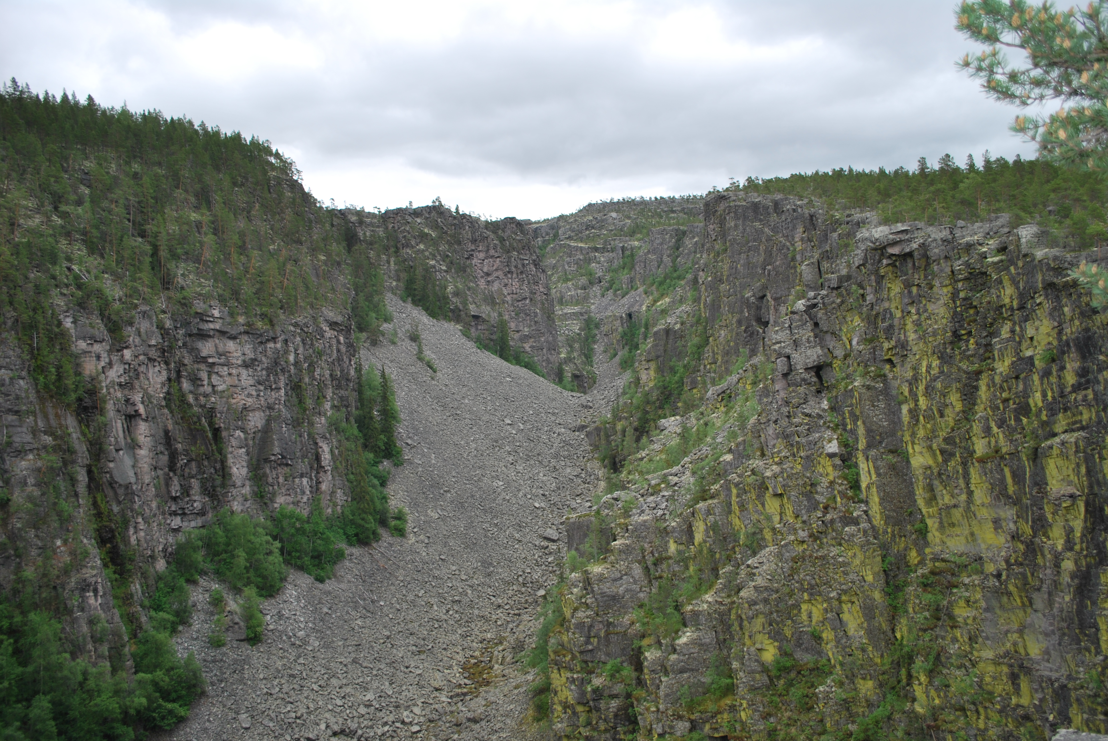
The first is Jutulhogget, a dry canyon cut by an ice-age flood roughly ten thousand years ago. It runs two and a half kilometres along the municipality’s western boundary, two hundred and fifty metres deep at the deepest point, with vertical walls in places. Norwegian geologists call it Northern Europe’s deepest dry canyon. There is a marked rim trail and an in-canyon trail. Both are short. Both are evidence that this landscape was carved hard and fast.
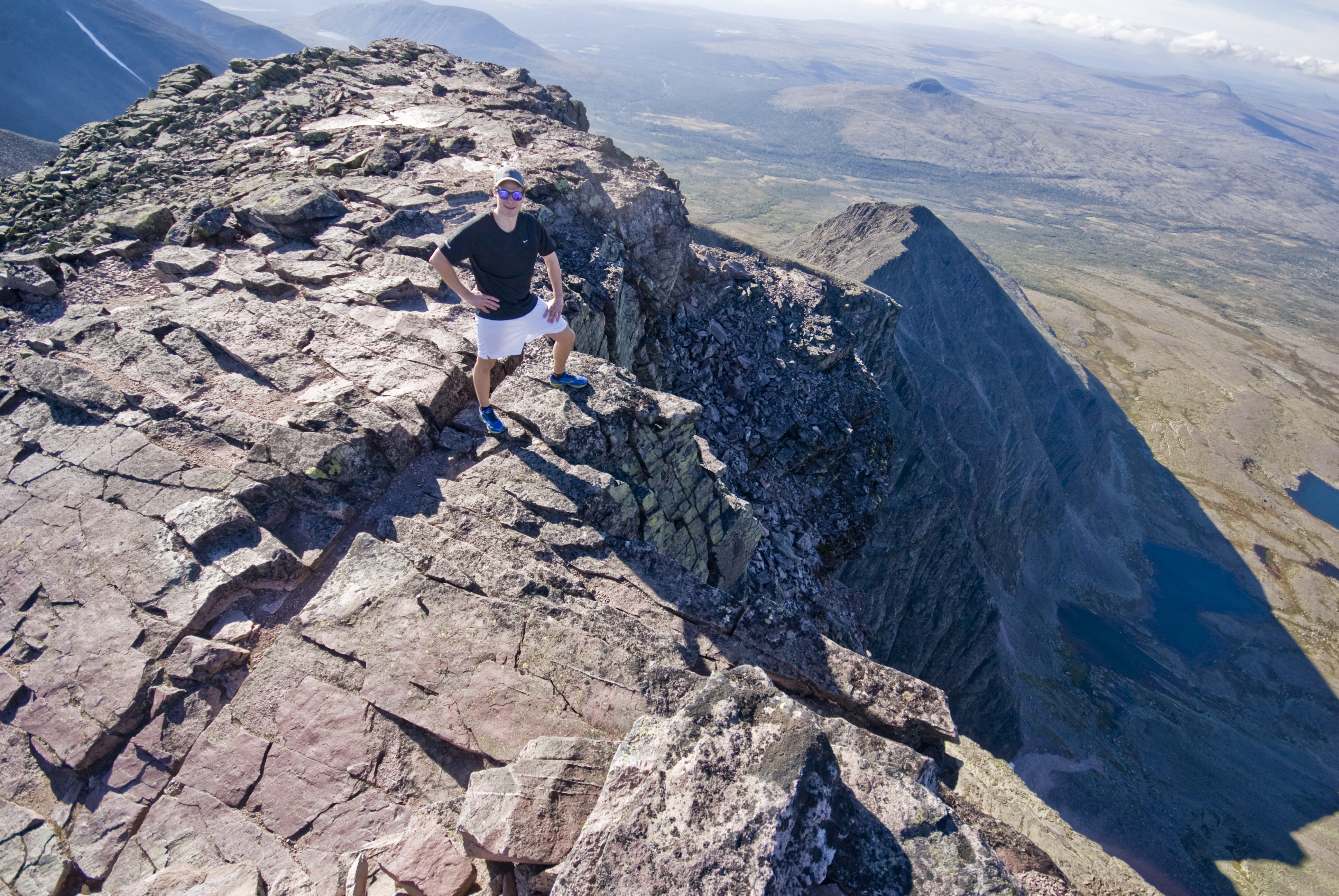
The second is Sølen, the protected landscape area established in 2011, covering roughly 460 km². Sølenfjellet rises in the middle of it. Rendalsølen, the southern peak, is the mountain on the cover of this article. The Sami used to call Sølen vaktarfjellet — the watch-mountain — because it is visible from a long way in every direction.
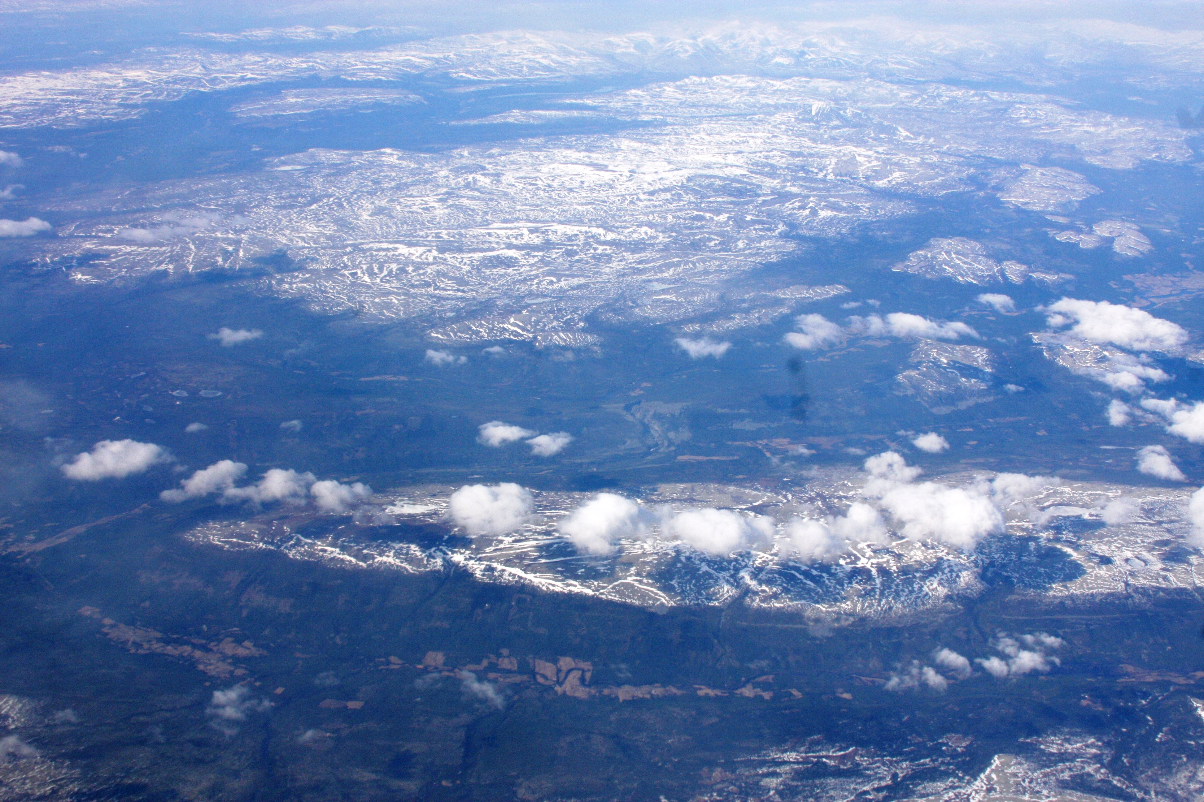
The third is the simple scale. Rendalen municipality covers 3,179 km². That is larger than the entirety of Vestfold county. Eighteen-hundred and fifty people live in it. The point of comparison is not just the area; it is the density. A road in Rendalen with no traffic on it is not a road that is briefly empty. It is a road that, on average, has no one on it.
The shared address
Other Scandinavian places have one of these three things. Some have two. Almost no one has all three within driving distance of the same village. The geography of upper Østerdalen is what does it — a wide valley running north-south, four big lakes strung along it, mountains rising on both sides, the canyon cutting in from the west, the national park bordering from the north, the protected landscape from the east. You can fish in the morning and walk into hunting terrain by lunchtime. The road network is small enough to learn in a week.
For comparison: Oslo has 1,649 people per km². Copenhagen has 7,108. Stockholm has 5,200. Rendalen is, by population density, about three thousand times less crowded than the Danish capital. The fishing is there because the lakes are there. The hunting is there because the forest and the plateaus are there. The nature is there because the people are not.
What it isn’t
An honest tagline acknowledges its limits. Rendalen is not Lofoten. It is not Geilo. It is not the Lyngen Alps. The municipality runs the line because of what it has, not because of what it pretends to have.
What we are not claiming
- Not the best saltwater fishing. That is Lofoten, Smøla, Senja. Rendalen is inland. The case is for freshwater.
- Not the biggest game. Reindeer in the high tundra of Hardangervidda are larger than Forollhogna’s. The Rendalen moose are average-to-good for Innlandet, not record-book.
- Not the most dramatic mountains. Rondane is taller and more vertical. The Lyngen Alps are sharper. Sølenfjellet is on the gentler end of Norwegian peaks.
- Not the easiest to reach. The nearest airport is Røros (45 min) or Oslo Gardermoen (3 hrs by car). The Røros line train stops at Hanestad.
- Not the warmest summer. July averages 13°C. June and August are cooler. Cold-water lakes do not warm up much.
The line never claimed any of those things. It claimed three things together, in one address. The line still holds because the three things still hold.
Why the line still earns it
Most municipalities’ old taglines collapsed because the place they described had collapsed. The brewery closed. The shipyard moved. The slogan kept saying something the town no longer was. Rendalen’s line did not collapse because the things underneath it — the lakes, the forest, the moose, the canyon, the protected landscape — have not collapsed. The fishing rights cooperative on Sølensjøen is in its eight-hundredth-some year. Forollhogna national park has been protected since 2001. Jutulhogget has been there since the ice retreated. The line still says something true about the place, in the same words, after thirty years.
The honest version of the tagline is not «Welcome to one of Scandinavia’s best fishing, hunting and nature destinations.» The honest version is the same sentence with the implicit footnote: not all three at once. Few places carry all three. Rendalen is one of them. The line is still earned.
Sources
- Rendalen kommune — municipal services and tourism materials
- Opplev Rendalen — destination management
- Miljødirektoratet — protected landscape areas and national parks
- Statskog — state forest hunting permits
- Inatur — fishing and hunting permits
- Statistics Norway — municipal population and area
- Forollhogna nasjonalparkstyre